留
状
況
留
岸
壁
時
港
の
見
え
方
大
村
海
岸
左
青
燈
台
小笠原
小笠原父島二見港
Futami Port at Chichi-jima Island in Ogasawara Islands
27 05.63N 142 11.74E(青燈台中)
艇を留める位置の詳細は下記Google Mapで航空写真を選択し、拡大
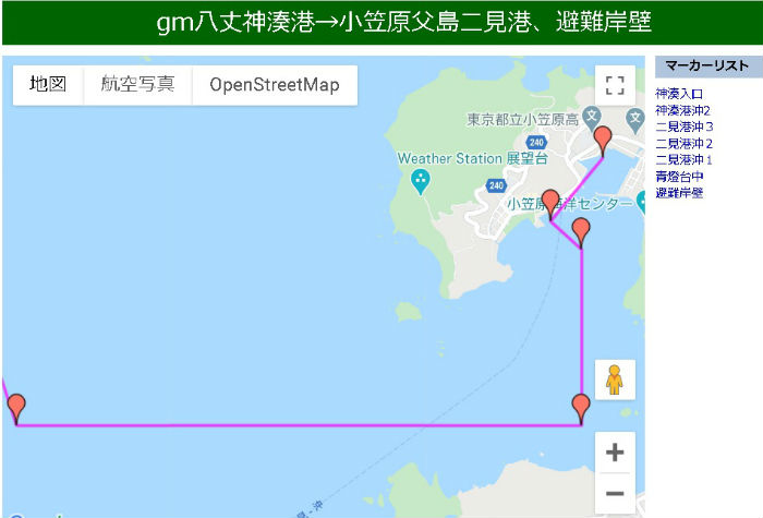
googlemap 八丈島神湊港→小笠原父島二見港、避難岸壁
googlemap 二見港避難岸壁→ふそう岩→熱海
上記、「避難岸壁」の27度 05.917 142度 12.010は
googlemapとGoogleEartに表示される位置から出した緯度経度です。
画像上で解りやすく仮に設定したもので、正確ではありません。
googlemapも写真で見て下さい。地図は詳細が無く正確ではありません。
航路情報
八丈島 神湊港→小笠原父島二見港
小笠原父島二見港→ふそう岩→熱海
BLOG
初めて、小笠原父島二見港にやって来ました。
小笠原父島二見港 泊地情報 2012.6.27 :
小笠原は沿海仕様では来ることができません。
近海が必要となります。
二見港へは明るい内に入港:
八丈島、神湊港から父島二見港までは389.9マイル。
平均5ノットの速度を仮定すると、約78時間、丸3日と6時間となります。
神湊港を5時に出港すれば、4日目の11時に入港となります。
日が暮れるまではまだ6時間はあります。
明るい内の入港を心がけてください。
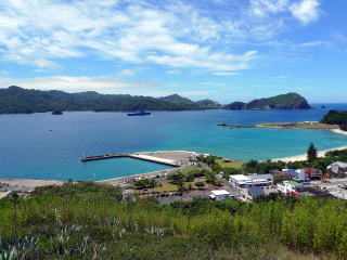
小笠原父島二見港へのアプローチ:
父島、二見港の入港に際しては、多くの船が座礁している。
二見港内でコースをショートカットすること無く、
以下のコースを順守して下さい。
1)二見港湾沖、27 04.7N 142 09.000に船を置く。
八丈島沖からは1本で行く位置である
2)上記位置からほぼ真東に要岩白塗標と丸山燈台(27 04.8N 142 12.5E)が見える。
3)二見港湾沖、27 04.7N 142 09.000から真東に白塗灯標を目指す。
(夜間は丸山指向灯の白光内を進めば、湾口両側の暗礁をさけることが出来る)
4)要岩手前、27 04.7N 142 11.9 で直角に左折し、二見港青燈台沖(27 05.500N 142 11.900E)を目指す。
5)二見港青燈台沖(27 05.500N 142 11.900E)に至った後、青燈台の内側(27 05.63N 142 11.7E)へ入る
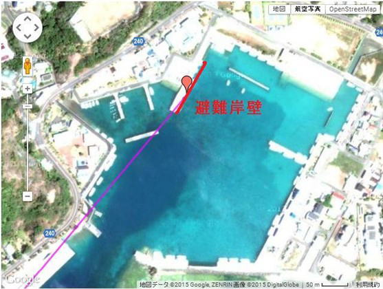
青燈台とは燈台が青く塗ってあるのでは無く、光が青と言う意味。
6)次に右折して漁港を目指す。
7)漁港入口には赤燈台が見える。赤燈台を右に見て、漁港に入る。
8)左に短い一文字堤防が見える
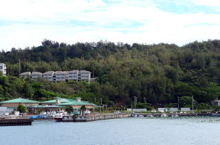
9)一文字堤防の先にグリーンの屋根の大きな建物が見える。
10)グリーンの屋根の建物の前の岸壁は「第四種避難港漁港」と呼ばれて、岸壁に「避難岸壁」書かれている。
11)漁港内でヨットを着けられのはこの「避難岸壁」である。
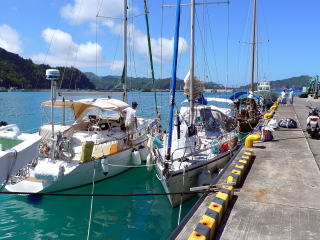
12)かっては、ヨットは青燈台裏に着けたが、今は静穏度の高い、漁港内、「避難岸壁」に着けることが出来る。
岸壁の裏はスロープになっている。
生活に便利なのは青燈台中だ。しかし静穏度を取って、奥の漁港に着けるのをお勧めする。
水:ポリタン程度は公園の蛇口ないしトイレから。
多量の場合村役場の建設水道課に連絡すると、 タンクローリーで給水に来てくれます。
料金は1トンでナント¥735
トイレ:岸壁から3分。洋式。
風呂:風呂は無い。トイレにはたいていシャワーが付いている。
燃料:スタンドあり。
コインランドリー:無し。
店:海岸に沿ったメインストリートに生協。その前に中型スーパー。食品は殆ど揃う。
食事:海岸に沿ったメインストリートに何軒もあり。
ただし、小笠原丸が出港してしまうと店が閉まってしまうので注意。
飲み屋:メインストリートと並行に1本入った通りに多い。
【小笠原行きの気象について】
1)いつ小笠原に向かうのが良いか。ヨットマンで気象予報士のKsayanに聞きました
Ksayanの答え
2)Ksayanに聞く、小笠原行きの気象についての留意点
3)小笠原父島までのKsayanとの気象に関する実際のやりとり
4)父島二見港から熱海まで、帰路でのKsayanとの気象に関する実際のやりとり
| 係 留 状 況 |
|
係 留 岸 壁 |
|
| 入 時 港 の 見 え 方 |
|
右 大 村 海 岸 左 青 燈 台 |
|
Futami Port at Chichi-jima Island in Ogasawara Islands
googlemap HatijyoKaminatoPort→OgasawaraFutamiPort
googlemap OgasawaraFutamiPort→Fusoiwa→Hatijyo→MiyakejimaAkoPort→Atami
June 27, 2012
Approaching Futami Port:
At the entrance of the port, many ships went aground.
When you approach the port, just follow the steps below. No shortcut.
1) Put your boat at 27 04.7N 142 09.000E off the port. You may draw a line
to this point from a point off Hachijo-jima Island.
2) At the point above, you may see Maruyama lighthouse(27 04.8N 142 12.5E) and white-colored Kaname-iwa (Kaname-lock) mark in
the east.
3) Then, head to the white-colored Kaname-iwa mark.
At night, follow the white color of the directional lights of Maruyama
lighthouse to keep out of the sunken rocks.
4) Turn left at a right angle at 27 04.7N 142 11.9E before Kaname-iwa,
and head to the point 27 05.500N 142 11.900E off the white light house
of Futami Port.
While the lighthouse has white-colored body, it is sometimes called the
“blue” lighthouse by local people, because it sheds a blue light at night.
5) Once you reach the point off the white lighthouse of the port, move
to the point 27 05.63N 142 11.7E inside of the lighthouse.
6) Then, turn right and head to the fishing port.
7) You may see the red lighthouse at the entrance of the fishing port.
Passing the red lighthouse to your right, move into the fishing port.
8) You may see a short one-line breakwater on your left
9) You may also see big buildings with green colored roofs behind the one-line
breakwater.
10) The quay in front of the buildings is called Type 4 Refuge Fishing
Port and has a painted sign 「避難岸壁」, which means Refuge Quay in Japanese.
11) It is the quay berth where you may moor your sail boat.
12) In the past, sail boats can be moored behind the white lighthouse.
It was convenient for living. But, I recommend the Refuge Quay berth
where is calmer as it is in the fishing port. There is a slope behind the
quay.
Water can be taken at a water tap at the park or the toilet.
If you need more water, call at the village office.
A big water tank truck will come to your boat with a cost of just JPY735/ton.
There is a western style toilet 3 minutes away from the quay.
While there is no public bath house, many of toilets have shower systems.
Fuel is at a gas station.
No coin laundry.
There are a CO-OP shop and a medium sized supermarket at the main street
along the shore.
No problem with shopping foods.
There are many restaurants at the main street. But, many of them are closed
after the ferry leaves for Tokyo.
There are many drinking places at a street behind the main street.
Additional Information for English Version
Ogasawara Village and Tourist Association have English web sites:
http://www.visitogasawara.com/
http://www.ogasawaramura.com/en/
Long distance Voyagers Association in Japan (LVAJ) is making an English
pilot of Futami and other ports:
http://cruisingjapan.org/mediawiki/wiki1/index.php?title=Futami