伊豆七島
伊豆大島 波浮港
Habu Port at Ohshima Island
34 41.200N 139 26.200E(波浮港手前導灯)
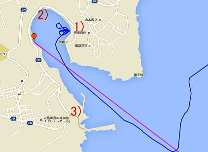
艇を留める位置の詳細は下記Google Mapで航空写真を選択し、拡大
Google Map熱海→波浮
Google Map大島波浮港 →利島港
航路情報
スパ・マリーナ熱海→伊豆大島波浮港
大島波浮港 →利島港
BLOG
6、7年ぶりに波浮を訪ねる
波浮港泊地情報 2012.4.30:
波浮港へのアプローチ:
波浮港は南東の強風以外はどの風も防ぎ、静穏で素晴らしい泊地だ。
ただ、入口は狭く、波立つことが多い。
入港に当たってのポイントは早くから、、導灯へ314.1度のコースを取ることだ。
このコースは港湾案内に指定している二つの導灯を結ぶ角度だ。
港湾案内にある二つの導灯は昼間には、初めての人に見つけ難い。
早くからこの角度を取ることで波浮港への入港航路の全体を見渡すことができる。
私は導灯まで、1マイル弱の34 40.650 139 27.080の地点に先ず船を持って行くことを勧める。
この地点から導灯までの角度は314度で導灯までの正確な入港針路となり、
かつ波浮港入口の全体を見渡すことができる。
波浮港内の係留地:
今回(2012.4.30)、漁協にレジャーボートの係留出来る場所を聞いてみた。
漁協の回答。
漁協前の水面すれすれの低い岸壁以外は空いている何処へ留めても良い。
との寛大な回答であった。
この空いているというのは、設置ブイが無いところと判断出来る。
実際にヨットが留められるのは
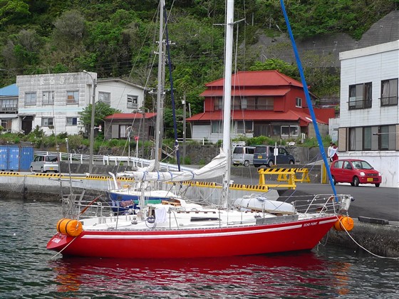
1)漁協前、低い岸壁の左端、一段高くなっている、虎模様の岸壁。
下記、係留状況の写真の左、虎模様の岸壁。
導灯へ314.1度で進み、港の中に入ったところで、右に進む。
右端には漁協、荷揚げ場がある。
この場所は岸壁が無く、海面すれすれの高さしかない。
その低い岸壁の左側に一段高くなった黒、黄の虎模様の新しい岸壁が空いている。
ここにモーターボートやヨットを留めることができる。
ただ、長さは横付けの場合、2艇から3艇しか留められない。
私は、5月の連休に行き、虎模様の岸壁がいっぱいだった。
そこで漁協寄り、低い岸壁の左端に留めたが特にクレームは無かった。
2)港の最奥、トイレの左の方。ここはブイが無い。昔ヨットを良く留めたところだ。
私が久しぶりに波浮に入った時、奥は本船でいっぱいであった。
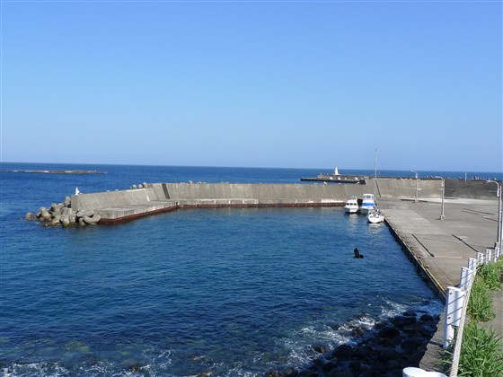
3)燈台の裏、波浮港に入る手前、港湾案内に三ツ磯とかかれた小さな船着き場。
波浮港内がいっぱいの時などに良い。クダッチ地区のスーパーには波浮港より近い。
下記の写真参照。
#注意!低い岸壁に横着けして、宿泊しないこと。
漁協から文句は出ないが、満潮時に水面と同じ高さになり、フェンダーが利かず、乗り上げる。
水:漁協。親切に対応してくれる。
港一番奥、トイレ脇に水道の蛇口。大量にタンクに入れる場合はこちらを使用。
ただし、大島の水道は海水を浄化、カルキも多いと観光案内所では飲水には勧めなかった。
燃料:港の一番奥に大きな看板で三崎屋商店、配送しますとあり。
風呂:港奥、トイレの裏の急坂を登ったところにある大島
カメリア イン リゾートホテル(旧ホットセンター波浮)600円
外食:漁協裏に寿司屋。クダッチ地区にも寿司屋その他あり
コインランドリー:カメリア イン リゾートホテルにて計画中
トイレ:洋式は港最奥のトイレ。いつも掃除されている。近いのはバス停後、旧港屋旅館前、和式
スーパー:約10分に4箇所。肉魚野菜あり。生活が出来る。
クダッチ(下地)地区。神社の上、波浮西岸バス停、トイレの所を右に上がって行く。
ゴミ:波浮の有難いのは、正式のゴミ捨て場があることだ。港最奥トイレの横。
泊地情報、航路情報一覧に戻る
| 泊地1) 【Berth1)】 | 泊地 【Berth】 |
|
|
| 燈台裏三ツ磯 泊地3) 【Berth3)】 | |
| |
Habu Port at Ohshima Island, Izu Seven Islands
34 41.200N 139 26.200E at the front guide light pole for the port
google map Habu Port at Ohshima Island→Toshima Island
google map Atami Port →Habu Port at Ohshima Islan
April 30, 2012
Approach:
Habu Port is a quiet excellent port which is protected well against winds
other than strong southeast wind.
But, the entrance area is choppy sometimes as it is narrow.
The key to enter is taking 314.1 degree course to align the two guide light
poles which stand in the back of the port.
Check the two guide poles and their direction on the chart and the port
guide.
It might be difficult for the first time visitor to identify the two white
poles during daytime.
Taking the 314.1 course earlier, you can take a whole view of your approaching
route earlier.
I would suggest you to put your boat first at 34 40.650N 139 27.080E which
is about 1 mile to the pole with 314.1 degree.
Berth:
This time, I asked Gyokyo, Fisheries Cooperative Association, which places
are good berths for pleasure boats.
They generously replied that any open place is OK for berthing other than
the just-over-the-water low quay in front of Gyokyo building.
I understood that the open places mean the places without buoys.
Then, the actual berthing places for sail boats are:
1) at a black-and-yellow striped quay which is in the left of the low quay
in front of Gyokyo.
The tiger-striped quay is shown in the left of picture below.
Once you enter the port with 314.1 angle to the guide poles, turn right.
Then, on your right, you will see Gyokyo building and an uploading area
which quay is very low and close to the sea level.
From the end of the low quay, there is the striped higher quay for pleasure
boats berthing.
But, the area length is just for a couple boats mooring alongside.
When I visited there Golden Week holidays in May, that berth place was
full.
Then, I moored at the low closer-to-Gyokyo quay next to the striped quay
though, I didn’t get any complain about it.
But, pay attention to the sea level.
As the sea level at flood time will be almost same with the quay level,
your fenders won’t work, your boat might ride over the quay.
2) at the innermost of the port in the left of the toilet. I used to moor
there, which has no buoy.
When I visited there this time, there was full of work boats.
3) at a small boat slip between the outmost breakwater lighthouse and the
original entrance of the port.
It is named Mitsuiso area on the port guidebook.
When the original port area is full, it is another good berth. It is
also closer to a supermarket at Kudachi area.
See the picture above.
Water is generously available at Gyokyo.
There is another water tap next to the toilet at the innermost of the port.
When you need a volume of water for your boat tank for example, use it.
But, as Oshima Island’s local water is made by purifying salty water and
smells like chlorine, “it is not suggested for drinking” the tourist information
center said.
Fuel: A big signboard at the innermost of the port says “Misaki-ya shop
delivers the fuel”.
There is a Sushi restaurant in the back of Gyokyo. Another Sushi and other
restaurants are in Kudachi area.
There is always-clean Western style toilet is at the innermost of the port.
A Japanese style toilet in front of ex Minato-ya Inn is in the back of
the bus stop.
There are four supermarkets in ten minutes away.
At areas of Kudachi, above the shrine, a bus stop at the west side of the
port and above the toilet.
Buying meat and vegetables, you can live here.
A good thing at Habu is that there is an official garbage at the innermost
of the port.
Additional Information for English Version
Tokai Kisen, a ferry company for Izu Seven Islands, has English introduction
of each island:
http://www.tokaikisen.co.jp/english/island/oshima/
Kuroshio, a strong ocean stream, is running through Izu Seven Islands.
As Kuroshio changes its course frequently, visit Japan Coast Guard’s weekly-updated
report:
http://www1.kaiho.mlit.go.jp/KAN3/kaisyo/kaikyo/sokuho/sokuho.html
Return to Cover Page