| 泊地情報
白石島新港 |
艇を留める位置の詳細は下記Google Mapで航空写真を選択し、拡大
Google Map 味野港マリーナUW1→白石島新港 2017.7.10
Google Map 白石島新港→弓削島 2017.7.11
Google Map 仁尾マリーナNio Marina→粟島→白石島新港2013.10.5
Google Map 白石島新港Shiraishijima island→小豆島吉田2013.10.6
Google Map 弓削島→白石島新港2014.10.1
Google Map 白石島新港→直島宮之浦2014.10.2
Google Map 直島宮之浦→白石島2014.6.5
Google Map 白石島→弓削島2014.6.7
航路情報
白石島新港→弓削島 2017.7.11
白石島新港Shiraishijima island→小豆島吉田
仁尾マリーナNio Marina→粟島→白石島新港Shiraishijima island
白石島新港→弓削島2014.6.7
直島→白石島新港2014.6.5
弓削島→白石島新港2014.10.1
白石島新港→直島2014.10.2
BLOG
白石島着 2017.7.10
瀬戸内国際ヨットラリーで白石島新港へ 2013.10.5
白石島をゆっくり訪ねました014.6.6
白石島新港 泊地情報:
2017.8.22
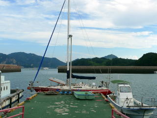
ポンツーン側に留める余地は殆ど無い。
私も今回、大型ヨットの前の狭い所に一旦留める。
その後、ヨットと反対側の船の人が来て、俵フェンダーが艇に当たっている。
すぐ移動しろと言われる。
見回りに来た、白石島の諸々の世話役をやっている原田さんも、
この移動しろと言っている人も浮き桟橋いに着けて良いと言っている。
空いている場合はこの桟橋に着けられるようだ。
空いていたのは先端部分だけだっとのでそこに移動。
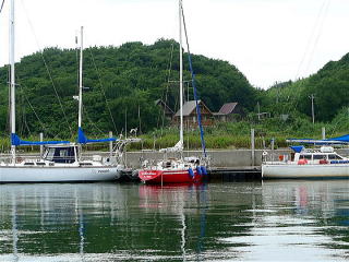
2017.7.10
ポンツーンの状況が非常によくなりました。
ポンツーンが長く岸壁に沿ってあるが、
昨年までは、廃船としか見えない小型船が全面的にポンツーンを占拠していた。
槍着けでも、留める余地は殆どなかった。
ところが、今年はそれ等の船は全て取り払われていた。
また、ポンツーンの上に散乱していた、ゴミとしか思えない釣り関連の諸材も廃棄されていた。
ポンツーンはきれいに全て空いていた。
しかし、私が寄港した時は36フィートぐらいの大型ヨット2艇が横着けしている。
ポンツーンを殆ど使ってしまっている。
その2艇の空いているところに槍着けした。
状況は非常によくなったと言って良い。
2016.8.11追記。
小さな釣り船が横付けされ、槍着けでも、船を着ける余地がなくなった。
横付けされた小さな船は動かないか、廃船だ。
私はスターンアンカー、槍着けで無理やり狭い所に留めた。
かなり大きなヨットが奥の動かない艇に横抱きするのを見た。
タラップの付いたおくの浮き桟橋は空いていることが多い。
だれか艇に残る必要があるが、余地が有るところに横付けして問題無いと思われる。
2014.10.1
100m浮き桟橋はうまっており、スターンアンカー槍着けで着ける。
横付できるスペースは右端2艇分のみ。
殆ど艇に来た痕跡の無い船が浮き桟橋に繋いだままになっており、
横付出来るスペースは無かった。
2014.6.6
港湾案内には白石島は掲載されていない。
食材仕入れは1軒だけ小さなスーパーがある。あまのストアー
野菜、肉もあり一通りは入手出来る。魚は無い。
酒は郵便局の前。
24時間入れるトイレは白石島港フェリー乗り場前のみ。和式。
昼間ならB&G海洋センターを使わせてもらえる。
水の蛇口は白石島港港周辺にも何処にも無い。
白石島の人はみなおおらかでとても親切です。
2013.10.5
白石島新港へのアプローチ:
白石島新(東)港は東から見ると防波堤が南北に伸び、
レンガ色をしている。
新港の入り口は防波堤の左(南)の端に、南に開いている。
注意:
港は南に開いているが南からアプローチしてはならない。
必ず座礁する。
港入口の真東、34. 24.410N 133 31.800Eから
真西にある港入口、防波堤の左(南)の端34. 24.410N 133 31.550Eを目指す。
防波堤左端まで来て、ぐるりと右(北)に廻り、港内に入る。
西側に150mのポンツーンがあり係留できる。
基本的には槍着けと聞いている。
水:無い。私は倉庫にある蛇口を無断で使わせてもらいました
トイレ:無い。丘を越えてB&G海洋センター
風呂:無い。宿で可能。
コインランドリー:無い
其の他、設備は何もない。
泊地情報、航路情報一覧に戻る
New Port (or East Port) of Shiraishijima
Google Map Shiraishijima island→Shodoshima Island Yoshida
Google Map Nio Marina→Shiraishijima island
June 6, 2014
There is a small supermarket, at which you can buy vegetables and meats.
But, no fish. A liquor shop is in front of the post office.
A 24hr available Japanese style toilet is near the ferry gate in Shiraishi-jima
Port,
which is the old port closer to the center of the island. No water tap.
People here is kind and generous hearted.
Oct 5, 2013
The New Port (or East Port) is located at the east side of Shiraishi-jima
island.
When you approach from the east, you will see the brick-red breakwater
running from north to south.
The port entrance is open to the south at the south end of the breakwater.
But, do not approach the port from the south, because there is danger of
going aground.
You should approach from the east.
Take the route from 34.24.410N 133 31.800E to 34.24.410N 133 31.550E
which is the south end, or the left end when you approach from the east,
of the breakwater.
When you reach the port entrance between the breakwaters, turn your boat
right to the north direction to enter.
In the port, you may moor at the 150 meter long pontoon (red line in the
map below) located at the west side of the port.
The bow-to is the basic though, you may sometimes moor alongside as you
see in the picture below.
No water, no toilet or no shower.
Toilet can be used at a building of B&G Foundation located beyond the hill.
Additional Information for English Version
The port is just for local commercial fishing boats.
Then, there is no facility or services for pleasure boats coming from outside.
| 2017.8.22の桟橋係留状況 | |
| |
|
| 2017.77.10の係留状況 | |
| |
|
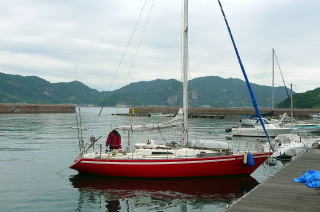
| 2016の係留状況 | 泊地、赤線部分 |
|